

Written by Margarita Kyrkou, surveyor and gis specialist at Wattcrop.
What is GIS system?
The need for spatial data has been known to spatial scientists since antiquity. The rapid development of technology led to the solution of the problem, with the emergence of Geographic Information Systems or GIS. The GIS system models space by gathering and combining a wealth of information. It has a database of geographic data and at the same time includes a database of descriptive data linked to the spatial data.
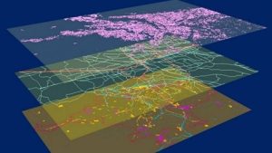
Geographic Information Systems are designed for the modern needs of managing and processing complex geographical data and are now used in a wide range of activities. GIS applications are growing in the current decade at an exponential rate and have been introduced in all productive sectors.
On the other hand, the continuous increase in energy consumption, its irrational use and the waste of the Earth’s natural resources have created a multitude of environmental, social, economic, political and integrated development problems. In this critical energy context, significant efforts are being made to strengthen and support Renewable Energy Sources.
Solar systems are one of the most competitive energy resources in the international and domestic market. In 2022, new business models could well be developed in the solar industry through increased demand for the development of solar co-storage (a combination of solar panels and batteries) – which have the main benefit of storing excess generation to balance demand. However, the uncontrolled and unplanned siting of photovoltaic systems does not help to make the best use of solar energy.A solution to this problem is provided by Geographic Information Systems technology.
What is the contribution of the GIS system in various sectors?
Geographic Information Systems technology contributes significantly to the spatial analyses and imaging methods necessary for information gathering and decision making. The intelligent location generated helps to identify the right location with the highest return on investment by combining spatial data with cost data. Apart from the development stage, they can also be applied during the planning and selection of geospatial strategy. It helps to be strategic and methodical in project development, which saves time and is critical in today’s world. There needs to be greater foresight as we look for energy opportunities.
By using location intelligence, stakeholders can apply the legislative criteria for selecting suitable sites, understand in advance how much energy a site can produce and then work with counterparts in the construction team to determine both costs and operating conditions.
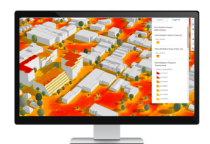
Regarding solar energy, GIS systems allow the mapping and analysis of the sun in a geographical area for specific periods of time. The atmospheric effects, the geographical position and altitude of the site, the inclination and direction of the sun, its daily and seasonal shifts and the effects of shading of the surrounding area are considered. The resulting results can be easily integrated with other Geographic Information System data and can help to model physical and biological processes, such as those affected by the sun. Suitability analyses are also carried out to identify any costly or difficult obstacles that may arise, such as safety, urban or environmental issues.
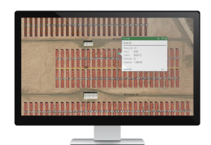
Geographical Information Systems have also made data collection processes more efficient. Users through applications that are released collect and organize data, transmitting it directly and quickly with the office and with stakeholders. Thus, enhancing the efficiency and digital transformation of processes.
Advantages are also identified in the quality control of procedures, the submission of applications and reports, and the monitoring of schedules and budgets. Also, when monitoring the construction and operation of each project. For example, fieldwork teams can complete data forms in order to identify potential development issues, and inspectors can have the ability to easily visually visualize where work needs to be done. Thus, this simple workflow improves inspection efficiency.
As you can see, there are many little secrets to the success of a project.
Having the ability to look at a huge amount of information and simplify it down to what we need to see is amazing.